google-site-verification=eqwDp6v4570NQpwD1V9-OmDXFbTQyWDwwwPvX4BwJdQ

READERS’ RIDE

This entry is part 7 of 26 in the series AusMotorcyclist Issue#26

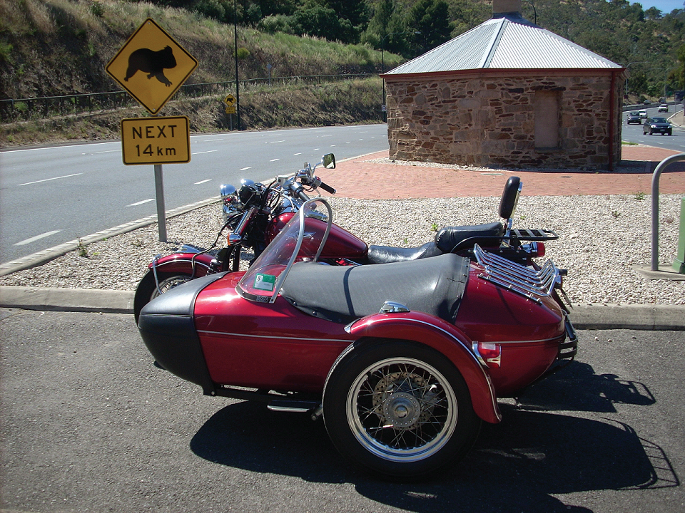
ADELAIDE HAS ITS OLD ROAD(S) TOO THREE WHEELS GO EAST WORDS/PHOTOS THE CHIEF

I started my day in “downtown” Adelaide. Well, not exactly “down town” Adelaide but the Toll Gate.

Now everyone, or most every one, in Adelaide and probably most people in South Australia know of the Toll Gate.

For you riders in other states, let me explain.

The Toll Gate House, as it should be called, is at the start of the South Eastern Freeway. It was built way back around 1841 when the government of the day in their wisdom decided to charge farmers bringing their produce to the markets. The idea was to help pay for the maintenance of the road into the hills but the maintenance didn’t happen and the road was more often than not in disrepair. The toll was discontinued in 1847 due to public outcries but the Toll Gate House building was left in place and has now been restored and is a land mark.

Let’s move on from the history of the Toll Gate, and take a ride out to Murray Bridge. Now you have a choice here. Follow the South Eastern Freeway all the way to the Bridge, and be a bit bored, or turn off at the Hahndorf exit, which is 16 kilometres from the starting point. A further 3 kilometres of riding through the little German inspired village founded by Captain Dirk Meinhertz Hahn in 1839.

Five kilometres on you will come to an intersection, to the right and over the Freeway is Mount Barker. But we don’t want to go there today.

Turn left and you are on the original Princes Highway. Yep! That’s the one that will take you all the way to Sydney, via Melbourne. This part of the old road winds its way through the villages of Littlehampton and Nairne, then on through some nice twisty hilly bits at what is known as Dawesley.

A few kilometres further on the road passes through Kanmantoo. Further still and the road bypasses Callington, another small village, in the Bremmer Valley.

Once you reach the top of the hill, stop and take in the view of the area you have just ridden through, it is quite picturesque, especially in the cooler months when all is green. In summer time when all around Callington is dry and browned off, Callington stands out as a green oasis. From this vantage point Murray Bridge is only fifteen minutes away. Enter Murray Bridge by the Princes Highway and it becomes Adelaide Rd. At the second set of lights the name changes to Bridge St. That, my fellow riders, is where you cross over the River Murray.

Leaving Murray Bridge, once the bridge itself has been crossed, the road once again takes on the name of the Princes Highway. Continue the short distance back to the Freeway and head for Tailem Bend, about 20 kilometres further on. If you desire more history call in to Old Tailem Town on the right just before the township of Tailem Bend, which is so named because it is situated on a large bend in the River Murray. My guess is that the rest of the name came from a Mr Tailem.

Old Tailem Town is a re-creation of a country town at the turn of the century.

A century ago, that is. It is worth a look. There is a small restaurant on site if you desire to have lunch or just stop over for a coffee, but anyway I urge you to spend a couple of hours wandering around this recreated old town.

Just out of town, the one with the Bend in its name, there is a sign that tells you where to turn right to get on the ferry that will take you to the other side of the river. The vehicular ferry may or may not be on your side of the river, if you have to wait rest awhile and take in the delights of the scenic beauty of the river and its surrounds.

Once on board the ferry you will have time to remove your helmet and enjoy the slow crossing of the mighty Murray.

Leaving the ferry behind, 13 kilometres ahead is Wentworth. There isn’t much at Wentworth although the pub is another good stopping point with excellent views over the river. If you cross on the ferry here you can ride in a left hand circular direction which will take you back to Tailem Bend. Turn right instead at the only intersection, you can’t miss it; you will have a 33 kilometre ride to Langhorne Creek. Depending on your point of view, and which season you are travelling in, this section of the ride can be classed as picturesque or otherwise.

The road is good with very little traffic; the surrounding country side is fl at to slightly undulating. Every so often you’ll see a glimpse of Lake Alexandrina to the left.

The pub at Langhorne Creek is another regular calling point. You can’t get lost in this very small dot on the map. Cross the bridge over the Bremmer River and you are in the main street which has one turn off to the right, opposite the pub, giving an excellent ride back through Woodchester to Mt. Barker.

If you decide to continue straight ahead for a further 14 kilometres, Strathalbyn is the next town to visit with its local history showing in some of its old stone buildings. At the round about where the fl our mill stands, continue straight ahead over the railway level crossing to the second round about, swing right and before you know it 25 kilometres on is Mt. Barker where you can rejoin the South Eastern Freeway and head back to Adelaide, passing the Toll Gate House once again at the bottom of the long down hill slope being mindful of the speed restriction signs.

The Man is watching!

Plenty of “horsepower” being blown out there…

Welcome to… Just don’t get bitten.

Series Navigation<< COMMUTING Special FeatureTEAR OUT MAP #26 >>
About the Author
Australian Motorcyclist Magazine is Australia's leading motorcycle travel magazine.

Related Posts

Page Scroller Supported By Bottom to Top